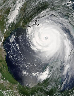
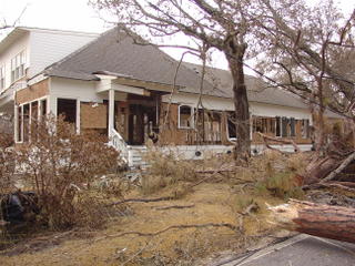
Hurricane Katrina Aftermath—Things I’ve Seen; Places I’ve Been
I spent an emotionally gruelling day over in Bay St. Louis and Waveland yesterday. I took over 250 photos. I rode along with an "offical" and was granted Beach access to areas that are not normally open....All I can say is HOLY COW!!!! What follows is my journal, with some of my favorite photos added. It's hard to pick from all the photos I took...there were so many.
Amazingly, I have ties to every one of these cities. I live in OS, my hubbs is from Long Beach and has family in Pass Christian. I have family in Waveland, and worked with folks who live in Bay St. Louis, and at one time served clients there as well. As a teen, I was on a Catholic Retreat Team (SEARCH), and had two team members from BSL and Waveland, and spent a lot time at their homes, which is why I have such ties to all the Catholic Churches on the Coast. I also served as the Catholic Youth Organization (CYO) Secretary for the Diocese of Biloxi which includes the entire Gulf Coast....As a VR counselor for the Deaf, I served the lower 6 counties of Mississippi, and while working at the Deaf Center we served something like 22 counties (man it's been a long time...Greg Crapo, the new Director would have to address that one!!! LOL!) Additionally, growing up, my dad provided many restuarants in the area with fresh seafood and stuffed crabs along the entire coast, and I can remember traveling to the different areas to deliver the seafood.
This storm has not only affected physical property that I own, it has also destroyed what I have left of memories of this Beautiful Gulf Coast....so instead of focusing on anger at what Katrina has done, I choose to focus on documenting....so that NO ONE FORGETS! It's the only way right now for me to stay sane. It's what I know and how I function.
NOTE: CLICK ON ANY PHOTO TO SEE AN ENLARGED PICTURE OF THE PHOTO IN ANY OF MY BLOGS!
+++++++++++++++++++++++++++++++++++++++++++++++++++++++++++++++++++++++++++++++++++++
Touring the Coast: Minute by Minute September 17, 20056:56 am I was fortunate enough to “bum” a ride with a state official because I was ready to see the devastation first hand. I had only seen the Ocean Springs area where I live and what lies between my house off of East Beach and my job at Mississippi Gulf Coast Community College, Jefferson Davis Campus in Gulfport. We were headed off toward Bay St. Louis. Before today, I haven’t felt “ready” to look at the devastation first hand, but now in an attempt to “move on”, I need to see this beloved Coast I’ve known so well and see what remains. I need to be able to look, document, grieve, and get on with the business of putting things back in order. This would include not only the physical, but also the emotional. It will be 3 weeks ago tomorrow that we left our home to evacuate to Tallahassee, FL, 3 weeks ago Monday that the storm hit, Tuesday will mark 3 weeks since Recovery began.
7:23 am I-10 traffic is good while making our way to the 603 exit in Bay St. Louis. I’m almost scared. We made a brief stop at the Woolmarket exit to fill up the State vehicle. Even though the truck’s gas gauge showed half full, no one is willing to risk venturing to “that” end of the coast without a full tank, I guess because of the scarcity of services. According to my chauffeur, “this end of the coast is basically 10-14 days behind in the recovery process due to being at lower elevation, and the difficulty of getting services back on line due to the sheer amount of devastation.”
7:31 am Riding along I-10 at Menge Avenue, the damage doesn’t appear to look much different than anything I have seen thus far. The typical visuals—trees down, wind and salt whipped Loblolly Pines have needles that appear brown-the same as if a controlled burn has taken place. All of the billboards have taken a tremendous beating. There is virtually no advertising left standing on I-10 at all. I’m surprised to see the green Highway Dept. Of Transportation signs announcing the distance to various communities still intact. “Diamondhead Exit 16—1 mile” remains unscathed, yet in Ocean Springs barely any of those signs remain standing.
7:39 am As we pass Diamondhead the tall signs announcing the gas stations and the Dairy Queen are all but gone. Could this be because of their high profile and the fact that they were made of glass?
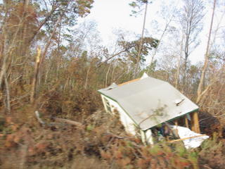
Riding up Highway 603 this is one of the many sights we saw....and there were countless duplications like it...! So SAD!!!
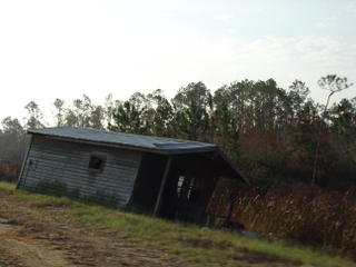
When the flood waters receded, the remains of this house came to rest right along the shoulder of Highway 603.
8:34 am We just left the Hancock County Wastewater District Treatment Plant. Oh my God!!!! The water was up to the rafters in that building. It was a total loss, yet they are still working out of it to get water and sewer on line to the people of Hancock County.
The Animal Shelter was set up behind it and I ventured off to visit the animals that have been rescued. I was told that most are being shipped to Hattiesburg. Yesterday, a pig was brought in. The Shelter is filled with food, water, cat litter, pet cages, and basically anything a family would need to adopt a new pet. While there, a special 18 wheeler drove in from the Humane Society to transport another load of animals to special shelters in safe locations farther north. It’s amazing what they are doing for these animals, and the love and care they are giving them.
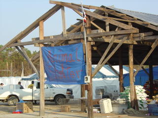
The Makeshift Animal Shelter in Hancock County
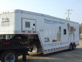
This is the comfort trailer that the Missouri Humane Society brought in for transporting rescued animals to points farther inland...most are being sent to Hattiesburg, which is about 80 miles north, and from there, they are being transported to other areas of the country for adoption.
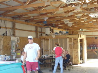
Hancock Water & Sewer District--With water up to the rafters--you can still see the remains of the debris still clinging to the rafters.
8:43 am We arrived at Bay St. Louis Public Works Department to begin the task of locating and highlighting the water and sewer lines on a map for the City of BSL to indicate any systems that may not be functioning at its full capacity. I have the overwhelming feeling of being in a war torn country. Spirits of folks I run into are high and that is encouraging. I’m taking it very easy on the fluid intake, as restroom facilities are hard to come by. I don’t want to have to “squat in the woods”!
9:06 am
I just spoke to a relief worker from CANADA! He was deployed by their military. I’m in awe at the military presence all around. It’s incredible! I thanked him from the “bottom of my heart for all of us here on the MS Gulf Coast”. His reply was simply “No problem”.
9:21 am The sound of Chinook choppers and Coast Guard Choppers fill the air in Bay St. Louis, MS. It seems that quiet is not something this once peace filled town has had since the recovery effort has begun. The city trucks all have logos that state “Bay St. Louis—A Place Apart”. For anyone who knows this quaint little town, this statement was true prior to Katrina—and now that she’s blown through, ironically, the statement still holds true, though with a different meaning!

City of Bay St. Louis vehicles all bear this logo....and never a truer statement there was!! Both before and after Katrina blew through this quaint town!
9:37 am At this early hour, less than 3 hours after setting out on our journey, I have had to refill the ice chest with ice and bottled water. All of the ice is melted, and most of the water has been drunk by me and my host of the day. Sweat pours from my head, face and neck. How LOVELY!! I can’t imagine being a relief worker having to work in the triple digit heat index. It was supposed to rain today, but there’s not a cloud in the sky!
10:06 am At the Public works compound, a variety of military vehicles and city vehicles travel in and out of the grounds moving toward their next mission of the moment. A thin layer of dust covers everything, including ME! The lack of rain since August 29th has left everything with a fine coating of grit. We passed cars and SUVs on I-10 today on the way that had “I survived Katrina” written in the settled dust. Clouds of dust are kicked up every time a vehicle leaves the compound leaving my nose, ears and eyes caked with fine gray sediment. I guess this is what the “dust bowl” area of Kansas was like during the drought in the 1930’s.
11:13 am We toured the 2nd Street area, Our Lady of the Gulf Catholic Church, St. Stanislaus High School and Old Town Bay St. Louis area. We saw the Highway 90 Bay bridge up close and personal and the CSX Railroad bridge, or should I say, what’s left of them. We are now on our way to the City of Waveland Southern Regional Wastewater Management District (SRWMD). I’m still in shock over what I’ve seen in Bay St. Louis and keep saying over and over, “Oh my God!”
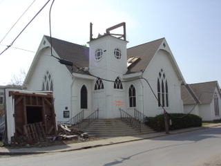
The remains of a Church in Old Town Bay St. Louis.
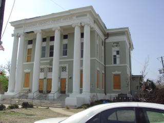
Hancock County Courthouse near OldTown Bay St. Louis
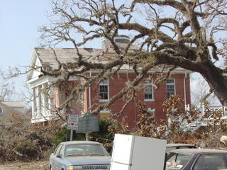
Bay St. Louis City Hall---The Crab Festival is held near this site--or should I say was--every year...The old oak tree seems to have fared well, but that was what I could tell from a distance.
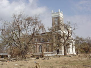
Our Lady of the Gulf (OLG) Catholic Church fronts Bayfront Drive on the beach in Bay St. Louis. The roof is gone, and who knows how high the water came in the inside.
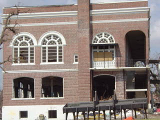
St. Stanislaus on the Beach in Bay St. Louis was heavily damaged.
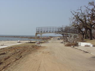
This walkway now leads to nowhere...at one time students from St. Stanislaus could walk to the beach....
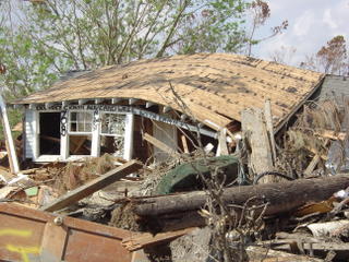
Though this 2nd Street home in BSL was totally demolished, the occupants leave a makeshift message ensuring loved ones that they were all alive. Click on the photo twice for a better read of the message.
11:41 am Well, he had no luck in locating the person he was looking for at SRWMD, and was told he may be at Buccaneer State Park which is on beach in Waveland, so…..off we go!!!
12:30 pm We pulled into Buccaneer State Park, and what a sight!!! FEMA trailers are coming in every minute. They have quite an operation going on out here. From talking to folks, these trailers are to be used for citizens who no longer have a place to live, which in Waveland is virtually everyone! It’s a nice sight to see. At first I thought these were being set up for city and county officials trying to get the infrastructure back up. While he conducted his business, I set out to tour the remains of the Wave Pool and the Water Slide area. It’s been cleaned up, but there’s not much left. I then went to the beach and amazingly the water looks great! The beach (sand area) is not bad either. Sadly, not one home stands.
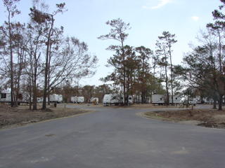
FEMA Trailers at Bucanneer State Park--These will be used for the citizens without homes in Waveland area--which is almost everybody!

What's left of the Water Slide at Buccaneer State Park.

This is what remains of the Wave Pool at Bucanneer State Park.
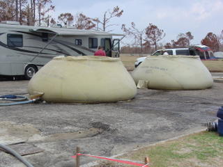
The US Navy is "making" water using reverse osmosis at this site, just off of the beach in front of Bucanneer State Park. This water will serve the FEMA trailer sites at the Park. The Navy uses this same process to provide drinking/potable water on all of their ships while at sea. They take sea water, and purify it, and hold it in these huge rubber bladders.
1:24 pm We left Buccaneer for a drive down the beach in Waveland so that I could take photos. I can’t believe what I am seeing. I am seeing lot after lot of NOTHING. Even the trees are gone for the most part. We came upon the area of what was once St. Claire’s Catholic Church and School, and the only thing standing on the ENTIRE lot was the brick grotto and the statue of the Virgin Mary. It brought tears to my eyes. I guess a good note was that lumber had already been delivered for what I assume to be used for construction of the new school. A sure sign that they WILL re-build!! This is more than I can handle, and more than I expected. Though I’ve heard stories, and seen aerial footage, the perspective is so different at ground
level.
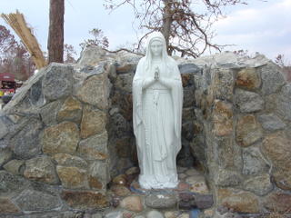 AMAZING
 is the only word I can think of to describe what I saw---This grotto at St. Claire's Catholic Church is the only thing that survived Hurricane Katrina! I had tears in my eyes as I was taking the picture.
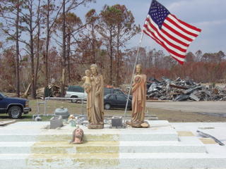
Holy Statues salvaged from the ruins and rubble have been placed on what was the Altar at St. Claire's Catholic Church in Waveland.
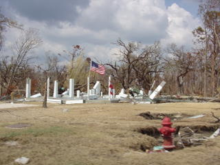
This is the typical visual as you drive down the beach in Waveland. Not a single house left. Flags fly on almost all of the lots, and many signs in the yards state "we WILL re-build"! It's overwhelmingly sad. The trees are even almost all but gone. The few that DO remain, are so wind and salt whipped, I wonder if they will recover!

Further inland from the beach (but not very far) off of South Central Avenue near Coleman...This picture reminds me of a scene from the movie
"TWISTER". This house was picked up and deposited near the CSX Railroad tracks.
1:48 pm We are now on our way back home, and I have to say I’m glad as hell. I’m emotionally drained. I don’t think I’ll ever forget the things I’ve seen. The rain has just started as promised in the forecast. As we travel back down Highway 603 headed toward 1-10, the rain dampened sludge that was caked and dried like a dried up river bed in a desert now fills the air with a putrid stench. While the rain is much needed, I feel so bad for the families with homes that have damaged roofs that have yet to begin their repairs. All I can think is God Bless our Beautiful Gulf Coast!
~~~~~~~~~~~~~~~~~~~~~~~~~~~~~~~~~~~~~~~~~~~~~~~~~~~~~~~~~~~~~~~~~~~~~~~~~~~~~~~~~~~~~~~~
NOTE: I could go on and on all day adding photos.....if anyone is interested in seeing an online photoablum of all the pictures I've taken, you can contact me at bgsigns9@bellsouth.net and I'll be happy to share the photos with you. However, they are not labeled, so if you're not familiar with the area, identifing what you are seeing is a challenge.


